
The Briefing:
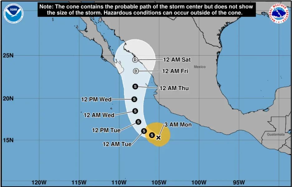
- Tropical Storm Vance carries 65 mph sustained winds as of Monday morning — down from a brief Category 3 peak of approximately 115 mph on Friday evening — and sits roughly 260 miles south-southwest of Manzanillo according to the National Hurricane Center's latest advisory.
- Forecasters project 2 to 4 inches of rain across Nayarit, Sinaloa and Colima through Thursday, with isolated totals up to 7 inches capable of triggering flash floods and mudslides across steep terrain in western Mexico.
- No coastal watches or warnings are currently in effect, but the inland flooding risk remains active through at least midweek — arriving days before millions of families begin Día de Muertos travel across the region.
A storm that briefly touched Category 3 hurricane strength last Friday evening is now drifting northwest off Mexico's Pacific coast as a weakening tropical system, carrying 65 mph winds and up to 7 inches of rain still possible across western Mexico this week — arriving exactly as millions of families prepare to travel for Día de Muertos, observed October 31 through November 2.
The timing places Mexican-American communities in California on high alert. Home-state families in Guerrero, Sinaloa, Nayarit and Jalisco — some of the most densely represented migrant-origin states in the U.S. — are watching Vance's northward progression with urgency as holiday travel decisions are finalized this week.
A Brief Category 3 Spike, Then a Rapid Retreat
Tropical Storm Vance hit Category 3 intensity with sustained winds of approximately 115 mph around Friday evening before losing strength rapidly and falling back to Category 2 through much of Saturday. According to the National Hurricane Center's Advisory 20, issued at 3 a.m. CST Monday, the system now carries maximum sustained winds of 65 mph as it drifts slowly northwest from a position roughly 260 miles south-southwest of Manzanillo. The National Hurricane Center's 2026 eastern Pacific storm log records Vance's peak at 100 knots — approximately 115 mph — placing it among the season's major hurricanes despite its current weakened state.
By Sunday morning the cyclone had already dropped to 75 mph, still qualifying as a Category 1 hurricane, before shedding hurricane status entirely Sunday afternoon at 70 mph. That rapid descent continued overnight, and Vance is now forecast to become post-tropical before the close of the week — though its rainfall legacy will outlast its winds by several days.
That northward track is what concerns emergency managers and diaspora communities alike. The storm's projected path runs along exactly the coastal stretch — Puerto Vallarta, Tepic, Culiacán — where millions of Mexican-origin families either live or plan to travel for the holiday week.

Rainfall, Not Wind, Is the Real Danger Now
Through Thursday, the National Hurricane Center projects 2 to 4 inches of rain across Colima, Nayarit and Sinaloa, extending into parts of Michoacán, Jalisco and Durango, with isolated totals reaching 7 inches in the most vulnerable pockets of steep terrain. That level of rainfall, saturating land already softened by months of Pacific season moisture, creates a category of risk that goes far beyond what the storm's wind speed alone suggests.
Mountain roads connecting coastal towns to inland cemeteries — the routes families travel every November 1 to visit gravesites — become vulnerable to mudslides, washouts and standing water within hours when rainfall concentrates on hillside terrain. For Monday specifically, swells of 4 to 5 meters are expected along the coasts of Colima, Jalisco and Michoacán, with wind gusts of 60 to 80 kilometers per hour forecast in coastal zones of those same states and the southwest of Guerrero.
What This Means for Día de Muertos Travel Starting Friday
Families planning to fly into Guadalajara (Jalisco) or Mazatlán (Sinaloa) — two of the most commonly used gateways for Mexican-American homeland travel — should build flexibility into itineraries before departure. While Vance is expected to weaken significantly before Día de Muertos begins October 31, its residual soil saturation effects will still affect road conditions across the region for days after the storm passes.
Travel insurance covering weather-related disruptions is especially worth confirming this week. Mexico's own advisories already note that heavy rains cause flooding and landslides between May and November — Vance is simply concentrating that seasonal risk into the most-visited travel week of the fall calendar.
Anyone with family in Guerrero, which sits at the storm's southeastern edge, should note that the state has been absorbing Vance's outer rain bands since the weekend and may see continued flooding in coastal and mountain-adjacent communities regardless of how the storm's track ultimately resolves.
A Record-Breaking Pacific Season Sets the Stage
Vance is the latest chapter in a Pacific hurricane season that has already exceeded pre-season projections, as a strengthening El Niño — currently tracking toward one of the strongest events in the historical record — continues to drive unusually warm sea surface temperatures across the eastern Pacific. The six named storms that immediately preceded Vance — Nolo, Odalys, Polo, Rachel, Simon and Trudy — each reached major hurricane intensity of Category 3 or above, per the National Hurricane Center's 2026 eastern Pacific storm log. Vance joined that group at its peak, making it the seventh consecutive named storm to reach major hurricane strength — a streak that illustrates how atmospheric conditions off Mexico's southwest coast remain primed for storm development even as November approaches and the season moves toward its November 30 close.
How to Track Vance Before You Travel
The NHC's official Vance advisory page publishes updates every six hours. The Weather Underground interactive tracker overlays the storm's projected path with rainfall forecasts in both Spanish and English. Mexico's national weather agency, CONAGUA, posts Spanish-language state-by-state alerts and is the primary source Mexican civil protection authorities use to issue local orders.
For families already in Mexico, the national emergency number is 911, which connects to police, emergency medical and civil protection services throughout the country. Mexico's Coordinación Nacional de Protección Civil (CNPC) also maintains a national coordination line at 800-003-3372. Local civil protection offices in Nayarit, Jalisco and Sinaloa are monitoring road closures and shelter availability in real time.
Do not rely on departure-day conditions to assess road safety. Vance's heaviest projected rain totals are concentrated Tuesday through Thursday — meaning the window between the storm's peak impact and the Friday start of Día de Muertos travel is narrower than 48 hours.
© {{Year}} Latin Times. All rights reserved. Do not reproduce without permission.